From the Columnist, Melinda Jo Ray: Sometimes in research one finds a piece of writing so appropriate that it must be shared in its original form. It provides both a glimpse of Acton’s early story and insight into the impact of growth and development in the modern Hood County we know, spawned by the 1969 damming of the Brazos River to form Lake Granbury. ENJOY!
In Her Own Words – An Article by Mary Lou Watkins – Written in 1975. A History of the Acton Community Prior to the War Between the States, the center of the present-day agricultural community of Acton was known as the Comanche Peak Post Office, Comanche Peak, / P.O., a designation chosen for its proximity to the highest point in the area some three or four miles to the west of Acton, Comanche Peak — a mesa clearly visible from the Acton community. Between Comanche Peak P.O. and Comanche Peak lay the Brazos River. Its fertile valley provided ample food and water for early travelers, and on its east bank the newcomers were relatively safe from marauding Indians. The Comanche Peak P.O. site was, therefore, a sensible terminal for settlers seeking a home in the west.
Moreover, the site was near (if not on) the old Spanish Trail which came up from South Texas and crossed the Brazos River near the present site of Granbury. This was probably the trail followed by the Butler and Lewis Expedition which set out from New Orleans Oct. 22, 1845, to make peace with the Indians. The Expedition got lost and ended up in Oklahoma. Meantime the Congress of the United States had voted to bring Texas into the Union; so, by the following March when the Expedition finally arrived back at Comanche Peak for the appointed meeting with the Nations, there was the important news that henceforth the Nations would be dealing not with the Republic of Texas, but with the President of the United States who had sent gifts. The Comanche, Delaware, Creek, Cherokee, Wichita, and Wacoan tribes were represented by their Chiefs and others camped on and around Comanche Peak. (Details of this meeting can be read in The History of Comanche Peak, Vance Maloney)
Previous to these attempted negotiations, Sam Houston had met on October 9, 1844, with Chief Buffalo Hump and Chief Old Owl in an attempt to define the line between the Indian hunting grounds and Texas proper. The Chiefs wanted the line to begin on the Brazos River and pass directly over Comanche Peak on its way south to the first stream west of the Colorado River below the San Saba, plus three days ride on a fast horse. (Frank Gaston Informal History of Texas.) Such a demarcation would, it appears, have put San Marcus in Indian territory, and Mr. Houston could not agree to it.
Nevertheless, these conferences do establish the fact that Comanche Peak was well known by name and by location to both the Anglos and the Indians in the early days of Texas, and that the Comanche Trail passed along the west bank of the Brazos River at that point (a mile or two south of Granbury). It seems quite natural, therefore, that the first white settlement within sight of the mesa should be called Comanche Peak even though that settlement was across the river from the Peak. The Comanche Peak P.O., later the Acton Square, was never a thriving business location. It was not on a waterway, a railroad, or even later on a major highway. Acton was and is the community center of a loosely knit agricultural area.
In his 1895, History of Hood County, T. H. Ewell “In those ante bellum days (half forgotten by the survivors) there were in this section many men in connection with whose lives and conduct doubtless many incidents of interest worthy to be recorded existed; but so vaguely remembered as to defy absolute verification. “We know only that men came west and settled at Acton, were followed by their families and friends, and by 1855 had formed an isolated but fairly strong little community. There were Presbyterians, Baptists, Methodists, and Reformed Christians who built a church near Walnut Creek for services held once a month. Between this Union Church and Buchanan, then the seat of Johnson County, there was 15 miles of uninhabited prairie. Adjacent to the church was a cemetery where they buried first the wife of Mr. Wash. Hutchinson.
In the fall of 1855, Aaron Farris settled a mile below the church to build a water mill and a still house. Presumably the community was then complete, since in 1856 it was granted a U.S. Post Office named Comanche Peak. The first postmaster was James Plemmons. In May of 1857, Clarence P. Hollis was named postmaster. According to Ewell, the village of Acton was given its name by a Mr. Hollis, its first merchant; yet not until March of 1868 was the post office known as Acton. We postulate, therefore, that sometime between 1859 (James Allison replaced Hollis as postmaster) and 1867 (see deed ref. to Acton Square) the town of Acton was laid out and the Square donated by Clarence P. Hollis. (Hood County courthouse burned in 1875 and records were destroyed.)
Acton was never incorporated. It never concerned itself with lawmaking bodies or taxes or sewage or city water systems. The people lived apart — independent, self-reliant, yet giving freely to one another in time of need or stress. And the town was their gathering place. By horseback, buggy, and wagon, later by car, the solitary farm and ranch families came into Acton for mail, a few modest supplies, and to hear the gospel
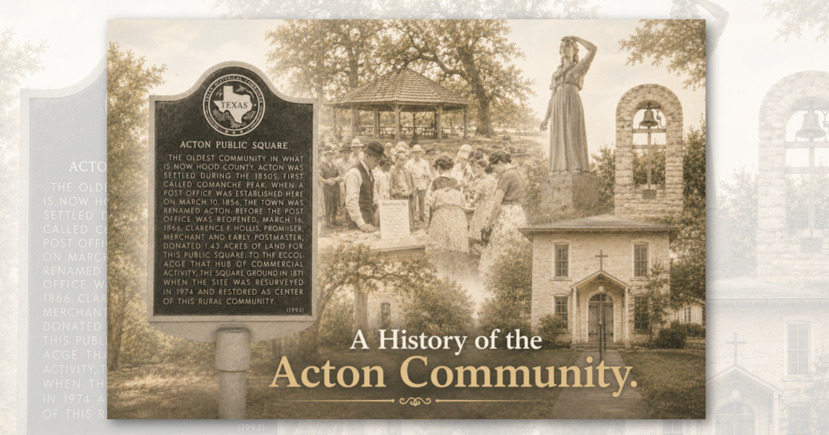
preached on Sunday. There were singings and cemetery workings, burials and lodge meetings. Acton remained a community, a place called home, and the Square is its symbol. The people of Acton want to mark their Square. It is the central point of the oldest settlement in Hood County, Texas.
Ewell History of Hood County pages 98, 99, and 100 of Ewells work tell the story of the Acton Masonic Institute, a Greek Revival stone structure presently being re-built by the Episcopal church. The grave of Elizabeth Crockett, wife of Davey Crockett of Alamo fame, is within a stones throw of the old Masonic Institute. This gravesite, in the Acton Cemetery, has the distinction of being the smallest state park in Texas.
Five years ago, the Brazos River Authority completed a dam across the Brazos River at DeCordova Bend (a bend of the river named for Jacob de Cordova who owned that land in the early days), creating a lake 34 miles long. The dam site is below Acton, but residential development is occurring all the way up the lakeshore to Granbury. For the most part, the new residents are retired people and commuters seeking a rural lifestyle. They are being absorbed into the community with a minimum of change.
Pecan Plantation and De Cordova Bend Estates built by the Leonard brothers (of the Fort Worth store by the same name) are perhaps the only two typically upper-middle-class suburban developments; in the area. Their ubiquitous golf courses and country clubs surrounded by 50 x 100 foot lots serve a need and have made it possible for many week-end people to build lovely homes in the area. In general, however, and in spite of the affluent times, the rural pioneer spirit prevails. Even the lake was built by private enterprise. There is no federal money in it, so the people can own and care for their land right up to the waters edge — a condition which makes for a minimum of empty cans and picnic trash.
The Acton Public Square is still the center of a typically Texas rural community. The people may bank in Granbury, shop in Fort Worth and Dallas, vacation in Canada, Mexico, or Europe — but Acton is still the place called home.